


Topography APP
Описание Topography APP
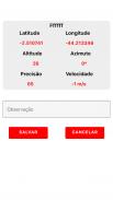
The Topography APP is an excellent application for georeferencing or land surveying, design of electrical networks, avenues, streets, subdivisions and studies in general.
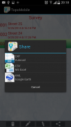
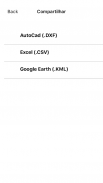
Export your surveys to DXF (Autocad), KML (Google Earth), CSV (MS Excel) without the slightest difficulty and the possibility of transmission by email of their withdrawals directly from the field to the office.
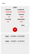
In the Professional version you can mark up to 5000 points for surveys.</div> <div jsname="WJz9Hc" style="display:none">Топография APP является отличным приложением для географической привязки или межевания, проектирования электрических сетей, проспектов, улиц, подразделений и исследований в целом.
Экспорт обследования для DXF (AutoCAD), KML (Google Earth), CSV (MS Excel) без малейшего труда и возможностью передачи по электронной почте их снятия непосредственно с поля в офис.
В профессиональной версии вы можете пометить до 5000 точек для исследований.</div> <div class="show-more-end">
Topography APP - Версия 2.3.4
(16-05-2020)Topography APP - Информация об APK
Версия APK: 2.3.4Пакет: aguiar.com.br.point_gpsПоследняя версия Topography APP
Другие версии


 4.63
4.63


Приложения в этой категории
 4.283.782.654.07
Вам также могут понравиться...


